
Gracias por apoyar a este sitio ❤️
Haz una donación
Haz una donación
Mapa topográfico Desert Mountain
Haga clic en el mapa para ver la altitud.
Gracias por apoyar a este sitio ❤️
Haz una donación
Haz una donación
Acerca de este mapa
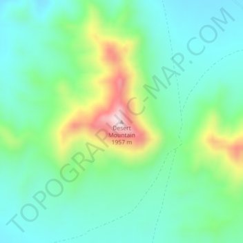
Nombre: Mapa topográfico Desert Mountain, altitud, relieve.
Lugar: Desert Mountain, Juab County, Utah, United States (39.78129 -112.59417 39.78139 -112.59407)
Altitud media: 1.673 m
Altitud mínima: 1.563 m
Altitud máxima: 1.953 m
Gracias por apoyar a este sitio ❤️
Haz una donación
Haz una donación
Otros mapas topográficos
Haga clic en un mapa para ver su topografía, su altitud y su relieve.
Eureka
United States > Utah > Juab County
Eureka is located in northern Juab County at 39°57′18″N 112°6′59″W / 39.95500°N 112.11639°W / 39.95500; -112.11639 (39.954974, -112.116364). It sits in the East Tintic Mountains at an elevation of 6,430 feet (1,960 m) above sea level. The northeast boundary of the city is the Utah County…
Altitud media: 2.048 m