
Mapa topográfico Mussoorie
Mapa interactivo
Haga clic en el mapa para ver la altitud.
Acerca de este mapa
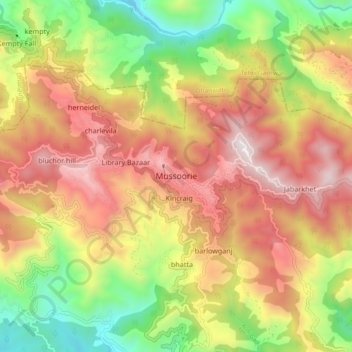
Nombre: Mapa topográfico Mussoorie, altitud, relieve.
Lugar: Mussoorie, Dehradun, Uttarakhand, 248179, India (30.41690 78.03829 30.49690 78.11829)
Altitud media: 1.594 m
Altitud mínima: 878 m
Altitud máxima: 2.285 m
Mussoorie is at an average altitude of 2,005 metres (6,578 ft). To the northeast are the Himalayan snow ranges, and to the south, the Doon Valley and Shiwalik ranges. The second highest point is the original Lal Tibba in Landour, with a height of over 2,275 m (7,464 ft). Mussoorie is popularly known as The Queen of the Hills.
Otros mapas topográficos
Haga clic en un mapa para ver su topografía, su altitud y su relieve.
Dehradun
India > Uttarakhand > Dehradun
Dehradun, Dehradun District, Uttarakhand, 248001, India
Altitud media: 904 m
Sahastradhara
India > Uttarakhand > Dehradun
Sahastradhara, Dehradun, Dehradun District, Uttarakhand, 248009, India
Altitud media: 1.100 m
Mohanpur
India > Uttarakhand > Dehradun > Dehradun
Mohanpur, Dehradun, Dehradun District, Uttarakhand, 248001, India
Altitud media: 599 m
Doiwāla
India > Uttarakhand > Dehradun
Doiwāla, Dehradun, Uttarakhand, 248140, India
Altitud media: 485 m