
Gracias por apoyar a este sitio ❤️
Haz una donación
Haz una donación
Mapa topográfico Hillary Step
Haga clic en el mapa para ver la altitud.
Gracias por apoyar a este sitio ❤️
Haz una donación
Haz una donación
Hillary Step
The step was named after Sir Edmund Hillary, who partnered with Sherpa Tenzing Norgay, on 29 May 1953 climbing the crack between the snow and the rock, earning the feature its name. Upon completion of the summit, the pair reported the snowpack on Hillary is harder than that of lower elevation.
Gracias por apoyar a este sitio ❤️
Haz una donación
Haz una donación
Acerca de este mapa
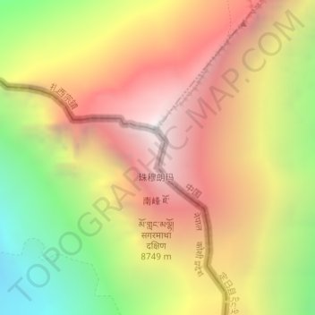
Nombre: Mapa topográfico Hillary Step, altitud, relieve.
Altitud media: 7.824 m
Altitud mínima: 6.597 m
Altitud máxima: 8.849 m
Gracias por apoyar a este sitio ❤️
Haz una donación
Haz una donación
Otros mapas topográficos
Haga clic en un mapa para ver su topografía, su altitud y su relieve.