
Mapa topográfico Charsadda
Haga clic en el mapa para ver la altitud.
Charsadda
Chārsadda (Pashto: چارسده; pronounce; Urdu: چارسدہ; pronounce) is a town and headquarters of Charsadda District, in the Khyber Pakhtunkhwa province of Pakistan. It is the 85th-largest city of Pakistan, according to 2017 census. Located in the Valley of Peshawar, Charsadda lies about 29 kilometres (18 mi) from the provincial capital of Peshawar at an altitude of 276 metres (906 ft). The total area of Charsadda District measures about 996 square Km. The district is geographically organized into two primary parts: Hashtnagar (Pashto: Ashnaghar) and Do Aaba (Pashto: Duaba).
Acerca de este mapa
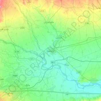
Nombre: Mapa topográfico Charsadda, altitud, relieve.
Altitud media: 317 m
Altitud mínima: 285 m
Altitud máxima: 417 m
Otros mapas topográficos
Haga clic en un mapa para ver su topografía, su altitud y su relieve.
Swat
Pakistan > Khyber Pakhtunkhwa > Charsadda District > بانڈہ سیداں > بِجلۍ کورونه
Altitud media: 370 m
Swat
Pakistan > Khyber Pakhtunkhwa > Charsadda District > بانڈہ سیداں > بِجلۍ کورونه
Altitud media: 370 m