Haz una donación
Mapa topográfico Groesbeek
Haga clic en el mapa para ver la altitud.
Haz una donación
Groesbeek
Due to this, the topography is much more varied here than in other higher grounds with similar origins in the Netherlands. Finally, during the Younger Dryas stadial, large amounts of loess were deposited in the valley, making it extremely fertile, while the hills around it are composed to this day of sandy loam unsuitable for intensive agriculture, so that the area has been covered with thick forests to this day. This contributed to the isolation of the area, especially considering the extent of the forests in the Middle Ages was much larger than today. The isolation of the valley was only alleviated by the arrival of the railway in 1865 and finally lifted in the interbellum by the construction of a high capacity paved road to nearby Nijmegen.
Haz una donación
Acerca de este mapa
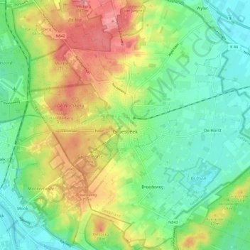
Nombre: Mapa topográfico Groesbeek, altitud, relieve.
Lugar: Groesbeek, Berg en Dal, Gelderland, Netherlands (51.74103 5.87940 51.81056 5.99207)
Altitud media: 41 m
Altitud mínima: 6 m
Altitud máxima: 93 m
Haz una donación
Otros mapas topográficos
Haga clic en un mapa para ver su topografía, su altitud y su relieve.