
Gracias por apoyar a este sitio ❤️
Haz una donación
Haz una donación
Mapa topográfico Summerford
Haga clic en el mapa para ver la altitud.
Gracias por apoyar a este sitio ❤️
Haz una donación
Haz una donación
Acerca de este mapa
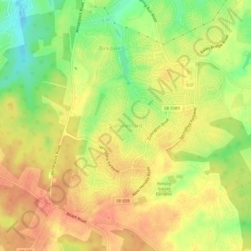
Nombre: Mapa topográfico Summerford, altitud, relieve.
Lugar: Summerford, Chesterfield County, Virginia, United States (37.35415 -77.68488 37.39415 -77.64488)
Altitud media: 87 m
Altitud mínima: 57 m
Altitud máxima: 106 m
Gracias por apoyar a este sitio ❤️
Haz una donación
Haz una donación
Otros mapas topográficos
Haga clic en un mapa para ver su topografía, su altitud y su relieve.
Bon Air
United States > Virginia > Chesterfield County > Bon Air
In the 19th century, it was believed that the higher elevation and distance from the urban area of Richmond provided a more healthful atmosphere, particularly in the hot summer months in central Virginia. With its nearby location and greater elevation, Bon Air offered these features nearby, and was founded as…
Altitud media: 87 m
Gracias por apoyar a este sitio ❤️
Haz una donación
Haz una donación