
Haz una donación
Mapa topográfico White Canyon
Haga clic en el mapa para ver la altitud.
Haz una donación
Acerca de este mapa
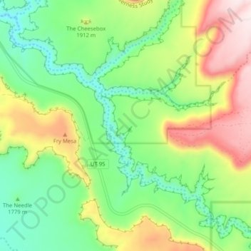
Nombre: Mapa topográfico White Canyon, altitud, relieve.
Lugar: White Canyon, San Juan County, Utah, United States (37.59796 -110.10933 37.65158 -110.03116)
Altitud media: 1.841 m
Altitud mínima: 1.624 m
Altitud máxima: 2.193 m
Haz una donación
Otros mapas topográficos
Haga clic en un mapa para ver su topografía, su altitud y su relieve.
Lake Powell
United States > Utah > San Juan County
Concrete placement started around the clock on June 17, 1960. The last bucket of concrete was poured on September 13, 1963. Over 5 million cubic yards (4,000,000 m³) of concrete make up Glen Canyon Dam. The dam is 710 feet (216 m) high and the surface elevation of the water at full-pool is approximately 3700…
Altitud media: 1.555 m
Oljato–Monument Valley
United States > Utah > San Juan County
Oljato–Monument Valley is located at 37°0′38″N 110°14′34″W / 37.01056°N 110.24278°W / 37.01056; -110.24278 (37.010556, -110.242778), at an elevation of 1,475 m (4,840 feet).
Altitud media: 1.557 m
Haz una donación
Monticello
United States > Utah > San Juan County
Monticello is located at the base of the Abajo Mountains, or the Blue Mountains, which are part of the Manti-La Sal National Forest. The elevation of Monticello is 7,069 feet (2,155 m). From Monticello, a tree formation on the Blue Mountains can be seen, which resembles a horse's head and neck, which can be…
Altitud media: 2.145 m
Haz una donación
Haz una donación