
Gracias por apoyar a este sitio ❤️
Haz una donación
Haz una donación
Mapa topográfico Navalagunda
Haga clic en el mapa para ver la altitud.
Gracias por apoyar a este sitio ❤️
Haz una donación
Haz una donación
Navalagunda
Navalgund is located at 15°34′N 75°22′E / 15.57°N 75.37°E / 15.57; 75.37. It has an average elevation of 578 metres (1896 feet). It is situated 35 km from Hubli and is famous as the birth place of 'Jamkhanas', the floor covering woven using cotton ropes, a kind of flat & thin carpet. It is famous for the Holi festival. The world famous Ramling Kamanna and the famous Naglinga Swamy temple are in Navalgund, as well as the famous Nilamma Tank
Gracias por apoyar a este sitio ❤️
Haz una donación
Haz una donación
Acerca de este mapa
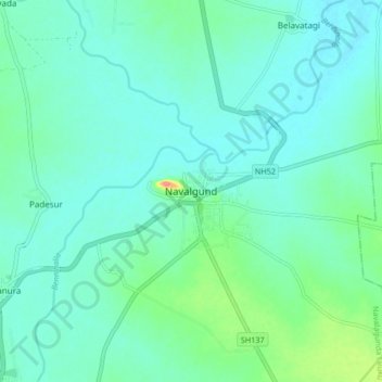
Nombre: Mapa topográfico Navalagunda, altitud, relieve.
Altitud media: 579 m
Altitud mínima: 564 m
Altitud máxima: 644 m
Gracias por apoyar a este sitio ❤️
Haz una donación
Haz una donación