
Haz una donación
Mapa topográfico Ismailli District
Haga clic en el mapa para ver la altitud.
Haz una donación
Ismailli District
The landscape is mainly composed of mountains. Altitudes vary between 200 and 3629 meters (Babadagh) above sea level. The area is passed by the Goychay, Gyrdyman, Akhokh, Ayrichay, Sulut and other rivers, Yekekhana and Ashygbayram artificial ponds.
Haz una donación
Acerca de este mapa
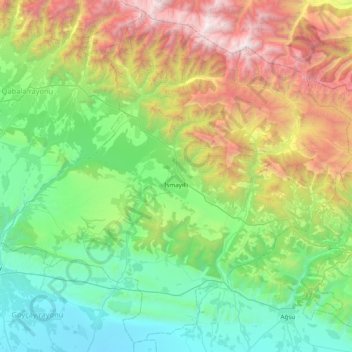
Nombre: Mapa topográfico Ismailli District, altitud, relieve.
Lugar: Ismailli District, Azerbaijan (40.52289 47.76271 41.07772 48.53859)
Altitud media: 1.009 m
Altitud mínima: 1 m
Altitud máxima: 3.632 m
Haz una donación
Otros mapas topográficos
Haga clic en un mapa para ver su topografía, su altitud y su relieve.
Haz una donación
Gadabay
Gadabay lies at the northern foot of the Shahdagh Range, at an altitude of 1460 meters, on the coast of the Mis River. The city is located in the middle and high mountainous areas of the Lesser Caucasus (also called Little Caucasus).
Altitud media: 1.499 m
Shirvan
Throughout its history, Shirvan has suffered from floods because of its proximity to the river and the relatively low elevation of most of the town.
Altitud media: 16 m
Haz una donación
Gazakh
Gazakh region is located in the western part of the republic, in the western part of the vast Ganja-Gazakh plain, which starts from the slopes of the mountain range of the Lesser Caucasus and extends along the right bank of the Kura river. The highest elevation is "Odun" mountain (1316 meters). Its nature is…
Altitud media: 382 m
Haz una donación