
Mapa topográfico Kasi
Haga clic en el mapa para ver la altitud.
Acerca de este mapa
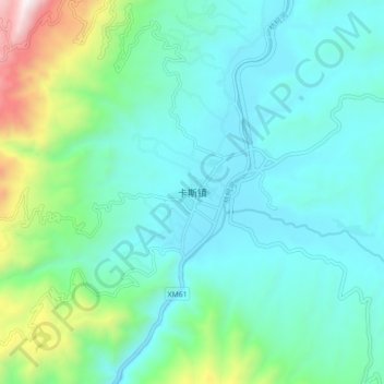
Nombre: Mapa topográfico Kasi, altitud, relieve.
Lugar: Kasi, Baoshan, Yunnan, China (24.74880 99.35200 24.82880 99.43200)
Altitud media: 1.179 m
Altitud mínima: 903 m
Altitud máxima: 2.283 m
Otros mapas topográficos
Haga clic en un mapa para ver su topografía, su altitud y su relieve.
Tengchong City
Situated at the southwestern end of the (transversely faulted) Hengduan Mountains, Tengchong topographically assumes the form of a horseshoe with the opening facing the south. The easternmost sources of the Irrawaddy River issue from the high mountains at the summit of Mount Danaozi of Gaoligong Mountain,…
Altitud media: 1.830 m