
Mapa topográfico Huancavelica
Mapa interactivo
Haga clic en el mapa para ver la altitud.
Acerca de este mapa
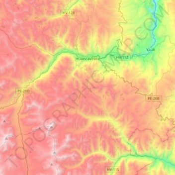
Nombre: Mapa topográfico Huancavelica, altitud, relieve.
Lugar: Huancavelica, Province of Huancavelica, Huancavelica, Peru (-12.97960 -75.21382 -12.70354 -74.87557)
Altitud media: 4.354 m
Altitud mínima: 3.226 m
Altitud máxima: 5.244 m
The Huancavelica area features a rough geography with highly varied elevation, from 1,950 metres in the valleys to more than 5,000 metres on its snow-covered summits. These mountains contain metallic deposits. They consist of the western chain of the Andes, which includes the Chunta mountain range, formed by a series of hills, the most prominent of which are: Sitaq (5,328m), Wamanrasu (5,298m) and Altar (5,268m).