
Mapa topográfico Talamet
Mapa interactivo
Haga clic en el mapa para ver la altitud.
Acerca de este mapa
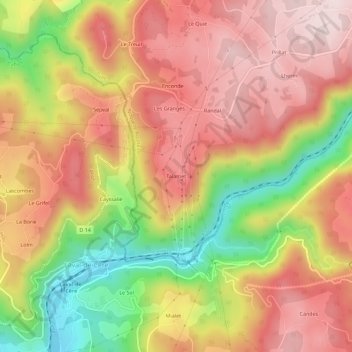
Nombre: Mapa topográfico Talamet, altitud, relieve.
Altitud media: 401 m
Altitud mínima: 159 m
Altitud máxima: 571 m
Otros mapas topográficos
Haga clic en un mapa para ver su topografía, su altitud y su relieve.
Saint-Mathurin Léobazel
France > Nouvelle-Aquitaine > Corrèze > Camps-Saint-Mathurin-Léobazel > Saint-Mathurin Léobazel
Saint-Mathurin Léobazel, Camps-Saint-Mathurin-Léobazel, Tulle, Corrèze, Nouvelle-Aquitaine, France métropolitaine, 19430, France
Altitud media: 542 m
Camps
France > Nouvelle-Aquitaine > Corrèze > Camps-Saint-Mathurin-Léobazel > Camps
Camps, Camps-Saint-Mathurin-Léobazel, Tulle, Corrèze, Nouvelle-Aquitaine, France métropolitaine, 19430, France
Altitud media: 505 m
Vidal
France > Nouvelle-Aquitaine > Corrèze > Camps-Saint-Mathurin-Léobazel > Camps
Vidal, Camps, Camps-Saint-Mathurin-Léobazel, Tulle, Corrèze, Nouvelle-Aquitaine, France métropolitaine, 19430, France
Altitud media: 508 m
Le Ventoux
France > Nouvelle-Aquitaine > Corrèze > Camps-Saint-Mathurin-Léobazel
Le Ventoux, Camps-Saint-Mathurin-Léobazel, Tulle, Corrèze, Nouvelle-Aquitaine, France métropolitaine, 19430, France
Altitud media: 549 m