
Haz una donación
Mapa topográfico Udhagamandalam
Haga clic en el mapa para ver la altitud.
Haz una donación
Udhagamandalam
Ooty is situated in the Nilgiri Biosphere Reserve. Many of the forested areas and water bodies are off-limits to most visitors in order to protect this fragile ecosystem. Some areas of the Biosphere Reserve have been earmarked for tourism development, and steps are being undertaken to open these areas to visitors whilst conserving the area. It is situated at an altitude of 2,240 metres (7,350 feet) above sea level.
Haz una donación
Acerca de este mapa
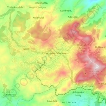
Nombre: Mapa topográfico Udhagamandalam, altitud, relieve.
Lugar: Udhagamandalam, Nilgiris, Tamil Nadu, 643001, India (11.37268 76.66305 11.45268 76.74305)
Altitud media: 2.234 m
Altitud mínima: 1.881 m
Altitud máxima: 2.622 m
Haz una donación
Otros mapas topográficos
Haga clic en un mapa para ver su topografía, su altitud y su relieve.
Government Botanical Garden
India > Tamil Nadu > Udhagamandalam > Udhagamandalam
Altitud media: 2.325 m