
Gracias por apoyar a este sitio ❤️
Haz una donación
Haz una donación
Mapa topográfico Mogok
Haga clic en el mapa para ver la altitud.
Gracias por apoyar a este sitio ❤️
Haz una donación
Haz una donación
Mogok
At 1,170 metres (3,840 ft) in elevation, the city has a fairly temperate climate year-round, and is home to Bamar, Shan, Lisu, Palaung, and Karen ethnic groups, as well as Chinese, Indians and Gurkhas. The city is composed of two towns, Mogok and Kyat Pyin. Mogok is four miles long and two miles wide. It is situated in a valley surrounded by a large number of mountains. Kyatpyin lies about 7 miles (11 km) southwest of Mogok. Tourists that travel to this area need a special authorization and a guide person.
Gracias por apoyar a este sitio ❤️
Haz una donación
Haz una donación
Acerca de este mapa
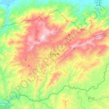
Nombre: Mapa topográfico Mogok, altitud, relieve.
Altitud media: 993 m
Altitud mínima: 173 m
Altitud máxima: 2.227 m
Gracias por apoyar a este sitio ❤️
Haz una donación
Haz una donación
Otros mapas topográficos
Haga clic en un mapa para ver su topografía, su altitud y su relieve.