
Haz una donación
Mapa topográfico Alwar
Haga clic en el mapa para ver la altitud.
Haz una donación
Acerca de este mapa
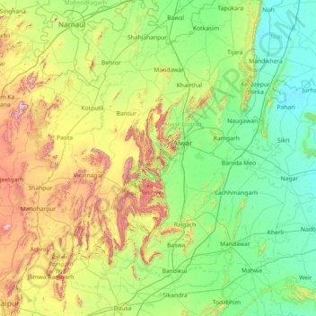
Nombre: Mapa topográfico Alwar, altitud, relieve.
Lugar: Alwar, Alwar District, Rajasthan, India (26.80000 75.80000 28.20000 77.20000)
Altitud media: 326 m
Altitud mínima: 181 m
Altitud máxima: 820 m
Haz una donación
Otros mapas topográficos
Haga clic en un mapa para ver su topografía, su altitud y su relieve.
Pokaran
India > Rajasthan > Pokaran Tehsil
Pokhran is located 112 km east of Jaisalmer city, 172 km northwest of Jodhpur and 225 km south of Bikaner by road. It lies on Jaisalmer to Jodhpur railway line. It is situated at 27°05′42″N 71°45′11″E / 27.095°N 71.753°E / 27.095; 71.753 and has an average elevation of 233 metres (764 feet).
Altitud media: 229 m
Haz una donación
Sirohi
Sirohi District is broken up by hills and rocky ranges. The granite massif of Mount Abu divides the district into two portions, running from north-east to south-west. The south and south-east part of the district, which lies between Mount Abu and the main spine of the Aravallis, is mountainous and rugged, and…
Altitud media: 351 m
Haz una donación