
Haz una donación
Mapa topográfico Laneville
Haga clic en el mapa para ver la altitud.
Haz una donación
Acerca de este mapa
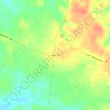
Nombre: Mapa topográfico Laneville, altitud, relieve.
Lugar: Laneville, Rusk County, Texas, 75667, United States (31.95433 -94.83383 31.99433 -94.79383)
Altitud media: 124 m
Altitud mínima: 99 m
Altitud máxima: 150 m
Haz una donación
Otros mapas topográficos
Haga clic en un mapa para ver su topografía, su altitud y su relieve.
Mount Enterprise
United States > Texas > Rusk County
The city of Mount Enterprise, located south of Henderson in rural Rusk County, was named for a small elevation near the town and for the business enterprise of the Vinzent brothers, who settled it in 1832.
Altitud media: 140 m
Mount Enterprise
United States > Texas > Rusk County
The city of Mount Enterprise, located south of Henderson in rural Rusk County, was named for a small elevation near the town and for the business enterprise of the Vinzent brothers, who settled it in 1832.
Altitud media: 140 m
Haz una donación