
Haz una donación
Mapa topográfico La Daille
Haga clic en el mapa para ver la altitud.
Haz una donación
Acerca de este mapa
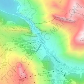
Nombre: Mapa topográfico La Daille, altitud, relieve.
Altitud media: 2.218 m
Altitud mínima: 1.694 m
Altitud máxima: 2.944 m
Haz una donación
Otros mapas topográficos
Haga clic en un mapa para ver su topografía, su altitud y su relieve.
Aix-les-Bains
France > Auvergne-Rhône-Alpes > Savoy
Aix-Les-Bains is located in the southeast of France, 107 kilometres (66 mi) east of Lyon. The town is located in a corridor between the mountain of Mont Revard, the first natural rampart of the Massif des Bauges to the east and the Lac du Bourget, the largest natural lake of France to the west. Thus, the city…
Altitud media: 348 m
Saint-Michel-de-Maurienne
France > Auvergne-Rhône-Alpes > Savoy
Saint-Michel-de-Maurienne has a oceanic climate (Köppen climate classification Cfb). The station is located at an altitude of 700 m (2,300 ft); due to its location on a leeward slope, there is significantly less precipitation than nearby areas. It is quite common to exceed 30 °C (86 °F) in summer, sometimes…
Altitud media: 1.590 m
Haz una donación
Saint-Jean-de-Maurienne
France > Auvergne-Rhône-Alpes > Savoy
Saint-Jean-de-Maurienne is on the route of the future Lyon-Turin rail link. Homes, businesses, the current railway station and the rescue centre are affected by the project. The Lyon Turin Railway company (LTF) which manages the construction projects plans to build new railway station in the Sous-le-Bourg…
Altitud media: 946 m
Haz una donación
Le Charvet
France > Auvergne-Rhône-Alpes > Savoy > Bourg-Saint-Maurice > Arc 1800
Altitud media: 1.651 m
Bonneval-sur-Arc
France > Auvergne-Rhône-Alpes > Savoy
Bonneval-sur-Arc features an alpine climate due to its high elevation, just under the tree line. Its climate is characterised by very cold, snowy winters and cool, stormy summers.
Altitud media: 2.636 m
Haz una donación
Haz una donación
Haz una donación
Haz una donación