
Mapa topográfico Custer County
Mapa interactivo
Haga clic en el mapa para ver la altitud.
Acerca de este mapa
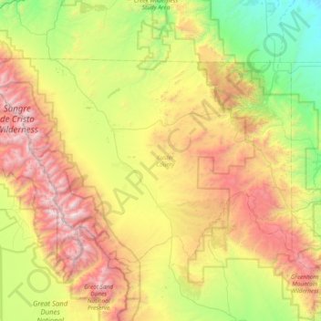
Nombre: Mapa topográfico Custer County, altitud, relieve.
Lugar: Custer County, Colorado, United States (37.88932 -105.79690 38.26602 -105.04681)
Altitud media: 2.616 m
Altitud mínima: 1.559 m
Altitud máxima: 4.306 m
The county is very rugged and would be virtually inaccessible without roads. The lowest point of the county is around 6,000 feet (1,800 m) in elevation, but most of the county is rugged and mountainous. The county seat of Westcliffe is about 7,800 feet (2,400 m) and along with nearby town Silver Cliff lies in the Wet Mountain Valley which sits at the base of the Sangre de Cristo Mountains. The peaks of the Sangre de Cristo Mountains to the west reach heights in excess of 14,000 feet (4,300 m) with Crestone Peak being the highest at 14,294 feet (4,357 m) and 7th highest fourteener in Colorado.
Otros mapas topográficos
Haga clic en un mapa para ver su topografía, su altitud y su relieve.
San Miguel County
San Miguel County, Colorado, United States
Altitud media: 2.357 m
La Plata County
La Plata County, Colorado, United States
Altitud media: 2.527 m
Costilla County
Costilla County, Colorado, United States
Altitud media: 2.655 m