
Haz una donación
Mapa topográfico Skegness
Haga clic en el mapa para ver la altitud.
Haz una donación
Skegness
Skegness fronts the North Sea. It is located on a low-lying flat region called Lincoln Marsh, which runs along the coast between Skegness and the Humber and separates the coast from the upland Wolds. Much of the parish's elevation is close to sea level, although a narrow band along the seafront is 4–5 m (13–16 ft) above peaking at 6 m (20 ft) on North Parade; the A52 road is elevated at 4 m (13 ft); and there is also a short narrow bank parallel to the shoreline between the North Shore Golf Club and Seathorne which is 10 m (33 ft) above sea level.
Haz una donación
Acerca de este mapa
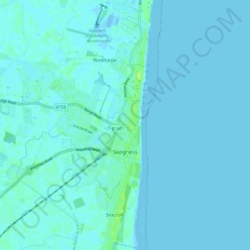
Nombre: Mapa topográfico Skegness, altitud, relieve.
Lugar: Skegness, East Lindsey, Lincolnshire, England, United Kingdom (53.12018 0.29858 53.18005 0.35683)
Altitud media: 2 m
Altitud mínima: -5 m
Altitud máxima: 12 m
Haz una donación
Otros mapas topográficos
Haga clic en un mapa para ver su topografía, su altitud y su relieve.
Saltfleetby St Peter
United Kingdom > England > Lincolnshire > East Lindsey > Saltfleetby St Peter
Altitud media: 3 m