
Haz una donación
Mapa topográfico Fultondale
Haga clic en el mapa para ver la altitud.
Haz una donación
Fultondale
Due to difficult topography, for many years Fultondale was limited in its ability to grow. However, as technology improved, the ability to convert what had been difficult to unusable land for retail and commercial purposes improved. The Colonial Promenade Fultondale development was a project of Colonial Properties and the first portion opened in the fall of 2007. It is home to many large as well as small retailers, shops and restaurants. Besides the retail development of Colonial Promenade, other retail development nearby includes various chain restaurants and large retailers. Other older, more mature business establishments line US 31 in the center of the community including supermarkets, casual fast food, banks, a bowling alley and skating rink.
Haz una donación
Acerca de este mapa
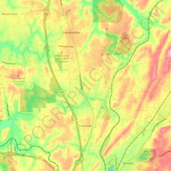
Nombre: Mapa topográfico Fultondale, altitud, relieve.
Lugar: Fultondale, Jefferson County, Alabama, 35068, United States (33.57883 -86.84855 33.67902 -86.73939)
Altitud media: 185 m
Altitud mínima: 86 m
Altitud máxima: 274 m
Haz una donación
Otros mapas topográficos
Haga clic en un mapa para ver su topografía, su altitud y su relieve.
Haz una donación
Haz una donación
Haz una donación
Haz una donación
Haz una donación
Haz una donación
Haz una donación
Haz una donación
Haz una donación
Haz una donación
Haz una donación
Haz una donación
Haz una donación
Haz una donación
Haz una donación