
Gracias por apoyar a este sitio ❤️
Haz una donación
Haz una donación
Mapa topográfico Strawberry Point
Haga clic en el mapa para ver la altitud.
Gracias por apoyar a este sitio ❤️
Haz una donación
Haz una donación
Acerca de este mapa
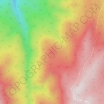
Nombre: Mapa topográfico Strawberry Point, altitud, relieve.
Lugar: Strawberry Point, Iron County, Utah, 84772, United States (37.75104 -112.94305 37.75114 -112.94295)
Altitud media: 2.436 m
Altitud mínima: 2.031 m
Altitud máxima: 2.690 m
Gracias por apoyar a este sitio ❤️
Haz una donación
Haz una donación
Otros mapas topográficos
Haga clic en un mapa para ver su topografía, su altitud y su relieve.