
Haz una donación
Mapa topográfico Kandhkot
Haga clic en el mapa para ver la altitud.
Haz una donación
Acerca de este mapa
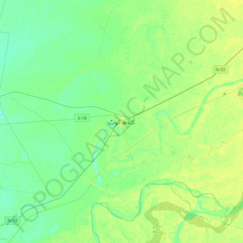
Nombre: Mapa topográfico Kandhkot, altitud, relieve.
Lugar: Kandhkot, Sindh, Pakistan (28.08490 69.02142 28.40490 69.34142)
Altitud media: 69 m
Altitud mínima: 62 m
Altitud máxima: 78 m
Haz una donación
Otros mapas topográficos
Haga clic en un mapa para ver su topografía, su altitud y su relieve.
Karachi Division
Karachi lies very close to a major fault line, where the Indian tectonic plate meets the Arabian tectonic plate. However, Karachi lies near the western edge of the Indian Plate, on the Indo Gangetic Plain. Within the city of Karachi are two small ranges: the Khasa Hills and Mulri Hills, which lie in the…
Altitud media: 89 m
Haz una donación
Karachi Division
Karachi lies very close to a major fault line, where the Indian tectonic plate meets the Arabian tectonic plate. Within the city of Karachi are two small ranges: the Khasa Hills and Mulri Hills, which lie in the northwest and act as a barrier between North Nazimabad and Orangi. Karachi's hills are barren and…
Altitud media: 89 m
Haz una donación
Haz una donación
Karachi Division
Karachi lies very close to a major fault line, where the Indian tectonic plate meets the Arabian tectonic plate. However, Karachi lies near the western edge of the Indian Plate, on the Indo Gangetic Plain. Within the city of Karachi are two small ranges: the Khasa Hills and Mulri Hills, which lie in the…
Altitud media: 89 m
Haz una donación
Haz una donación
Haz una donación
Haz una donación
Haz una donación
Haz una donación
Haz una donación
Karachi Division
Karachi lies very close to a major fault line, where the Indian tectonic plate meets the Arabian tectonic plate. Within the city of Karachi are two small ranges: the Khasa Hills and Mulri Hills, which lie in the northwest and act as a barrier between North Nazimabad and Orangi. Karachi's hills are barren and…
Altitud media: 89 m
Haz una donación
Haz una donación
Haz una donación