
Haz una donación
Mapa topográfico San Jose del Monte
Haga clic en el mapa para ver la altitud.
Haz una donación
San Jose del Monte
The elevation of the city ranges from approximately 40 to 900 meters (130 to 2,950 ft) above sea level; the relief transitions from warm lowland to cool upland as one goes eastward. This is because the city is part of the Sierra Madre mountain range. Plains and river valley flats characterize the western and southwestern quadrant. The central portion and much of its eastern section are made up of undulating hills with low relief. High relief areas and moderate slopes best describe its extreme eastern and northwestern quadrant. Slopes of 3%-8% are extensively found in the city, particularly in the western half. Slopes of 30%-50% comprise the smallest portion of the total land area.
Haz una donación
Acerca de este mapa
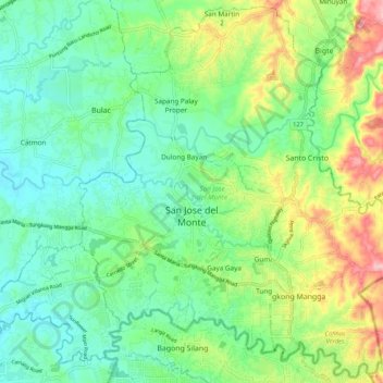
Nombre: Mapa topográfico San Jose del Monte, altitud, relieve.
Lugar: San Jose del Monte, Bulacan, Central Luzon, Philippines (14.76740 121.01659 14.86540 121.14936)
Altitud media: 73 m
Altitud mínima: 7 m
Altitud máxima: 263 m
Haz una donación
Otros mapas topográficos
Haga clic en un mapa para ver su topografía, su altitud y su relieve.
Malolos
Malolos is relatively flat of about 0.81% to a gently sloping of 2.17%. The slope of the land descends towards west, southwest to southern direction. The highest land elevation is at about 6.0 meters above sea level while the lowest is only half a meter below sea level. A network of natural waterways and…
Altitud media: 6 m
Haz una donación
Santa Maria
The topography of Santa Maria is generally flat, however, it is becoming hilly towards the north. This area covers the barangays of Silangan, Mag-asawang Sapa, Pulong Buhangin and some parts of Balasing with landscape ranging from 8 to 18 percent slope. The rest of the barangays have a slope range from level…
Altitud media: 18 m
Haz una donación
Haz una donación
San Jose del Monte
The elevation of the city ranges from approximately 40 to 900 meters (130 to 2,950 ft) above sea level; the relief transitions from warm lowland to cool upland as one goes eastward. This is because the city is part of the Sierra Madre mountain range. Plains and river valley flats characterize the western and…
Altitud media: 103 m
Haz una donación
Haz una donación
Haz una donación
Pandi
Pandi is rich in many natural brooks coming from the mainland itself. In some remote areas the lands are still covered by bamboo trees that naturally thrive and multiplies. Some lands privately owned have mango plantations. In some areas that are privately owned are rock deposits being used for housing…
Altitud media: 27 m
Haz una donación
Haz una donación
Haz una donación
Pandi
Philippines > Bulacan > Pandi
Pandi is rich in many natural brooks coming from the mainland itself. In some remote areas the lands are still covered by bamboo trees that naturally thrive and multiplies. Some lands privately owned have mango plantations. In some areas that are privately owned are rock deposits being used for housing…
Altitud media: 27 m
Haz una donación
Haz una donación
Haz una donación
Haz una donación
Haz una donación
Haz una donación
Haz una donación
Haz una donación
Haz una donación
Haz una donación
Haz una donación
Haz una donación
Haz una donación
Haz una donación
Haz una donación
Haz una donación