
Gracias por apoyar a este sitio ❤️
Haz una donación
Haz una donación
Mapa topográfico Naldurg
Haga clic en el mapa para ver la altitud.
Gracias por apoyar a este sitio ❤️
Haz una donación
Haz una donación
Naldurg
Naldurg is located at 17°49′N 76°18′E / 17.82°N 76.3°E / 17.82; 76.3, 438 km from Mumbai.50 km from Solapur city It has an area of 7550 km2 and average elevation of 566 metres (1856 feet). The temperature ranges from 10.1 °C to 43.1 °C, and the average yearly rainfall is 760mm.
Gracias por apoyar a este sitio ❤️
Haz una donación
Haz una donación
Acerca de este mapa
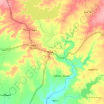
Nombre: Mapa topográfico Naldurg, altitud, relieve.
Altitud media: 563 m
Altitud mínima: 500 m
Altitud máxima: 621 m
Gracias por apoyar a este sitio ❤️
Haz una donación
Haz una donación
Otros mapas topográficos
Haga clic en un mapa para ver su topografía, su altitud y su relieve.