
Haz una donación
Mapa topográfico Matijevići
Haga clic en el mapa para ver la altitud.
Haz una donación
Acerca de este mapa
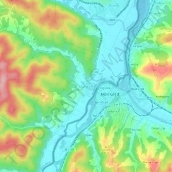
Nombre: Mapa topográfico Matijevići, altitud, relieve.
Altitud media: 168 m
Altitud mínima: 110 m
Altitud máxima: 280 m
Haz una donación
Otros mapas topográficos
Haga clic en un mapa para ver su topografía, su altitud y su relieve.
Haz una donación
Haz una donación
Grad Sisak
Croatia > Sisak-Moslavina County
Sisak (pronounced [sǐːsak]; also known by other alternative names) is a city in central Croatia, spanning the confluence of the Kupa, Sava and Odra rivers, 57 km (35 mi) southeast of the Croatian capital Zagreb, and is usually considered to be where the Posavina (Sava basin) begins, with an elevation of 99…
Altitud media: 132 m
Grad Sisak
Croatia > Sisak-Moslavina County
Sisak (Croatian pronunciation: [sǐːsak]; Hungarian: Sziszek [ˈsisɛk]; also known by other alternative names) is a city in central Croatia, spanning the confluence of the Kupa, Sava and Odra rivers, 57 km (35 mi) southeast of the Croatian capital Zagreb, and is usually considered to be where the Posavina…
Altitud media: 132 m
Haz una donación
Haz una donación