
Mapa topográfico Turk Mountain
Haga clic en el mapa para ver la altitud.
Acerca de este mapa
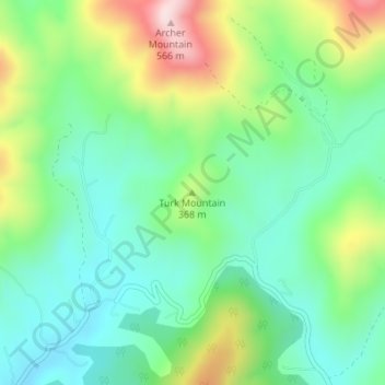
Nombre: Mapa topográfico Turk Mountain, altitud, relieve.
Lugar: Turk Mountain, Nelson County, Virginia, United States (37.88620 -78.77424 37.88630 -78.77414)
Altitud media: 309 m
Altitud mínima: 187 m
Altitud máxima: 564 m
Otros mapas topográficos
Haga clic en un mapa para ver su topografía, su altitud y su relieve.
Occoquan Bay National Wildlife Refuge
United States > Virginia > Prince William County > Woodbridge
Altitud media: 3 m
Blue Ridge
United States > Virginia > Loudoun County
Blue Ridge Mountain is noticeably lower in elevation than other sections of the Blue Ridge Mountains in Virginia. The southern section of the mountain contains the highest peaks, and the ridge gradually loses elevation as it gets closer to the Potomac. Elevations in the gaps are typically around 1,000 feet…
Altitud media: 183 m
Rustburg
United States > Virginia > Campbell County
Rustburg is located in north-central Campbell County at 37°16′25″N 79°05′56″W / 37.273731°N 79.098914°W / 37.273731; -79.098914 (37.273731, −79.098914). U.S. Route 501 passes through the center of town, leading north 11 miles (18 km) to Lynchburg and south 20 miles (32 km) to Brookneal.…
Altitud media: 262 m
Vinton
United States > Virginia > Roanoke County
Vinton has varied topography, considering its 3.2 square mile size. The above-mentioned lake is at an elevation of 890 feet (270 m) above sea level. The Vinton side of the lake consists of a steep, wooded cliff 150 feet (46 m) in vertical height. Vinton's highest point is on Olney Road, at an elevation of…
Altitud media: 305 m
Great Falls
United States > Virginia > Fairfax County > Great Falls
Great Falls is located at 38°59′53″N 077°17′18″W / 38.99806°N 77.28833°W / 38.99806; -77.28833 (38.9981653, −77.2883157) at an elevation of 344 feet (105 m). Located on Virginia State Route 7 in Northern Virginia, Great Falls is 15 miles (24 km) west-northwest of downtown Washington,…
Altitud media: 88 m
Wolf Trap National Park for the Performing Arts
United States > Virginia > Fairfax County > Wolf Trap > Shouse Village
Altitud media: 104 m
Kernstown Battlefield Park
United States > Virginia > Frederick County > Winchester > Valley Acres
Altitud media: 241 m
Barboursville Community Park
United States > Virginia > Orange County > Barboursville
Altitud media: 158 m
Painter
United States > Virginia > Accomack County
It lies at an elevation of 36 feet.
Altitud media: 10 m
Glade Spring
United States > Virginia > Washington County
The elevation is 2,087 ft above sea level.
Altitud media: 658 m