
Mapa topográfico Crested Butte
Haga clic en el mapa para ver la altitud.
Crested Butte
At the 2020 United States Census, the town had a total area of 535 acres (2.166 km2), all of it land. Crested Butte lies at an elevation of 8,885 feet (2,708 m) above sea level.
Acerca de este mapa
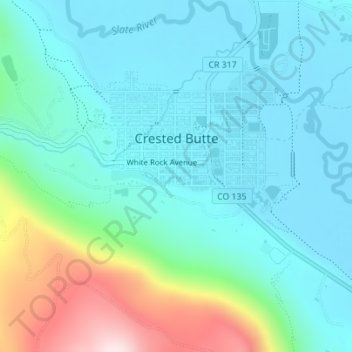
Nombre: Mapa topográfico Crested Butte, altitud, relieve.
Altitud media: 2.798 m
Altitud mínima: 2.693 m
Altitud máxima: 3.177 m
Otros mapas topográficos
Haga clic en un mapa para ver su topografía, su altitud y su relieve.
Gunnison
United States > Colorado > Gunnison County
Also in 1880, the cattle industry in Gunnison was established. Realizing the poor conditions for farming (with only about eleven inches of rainfall annually and the short growing season due to the high elevation and alpine environment) the local farmers turned to ranching and began breeding cattle. To do this…
Altitud media: 2.369 m