
Haz una donación
Mapa topográfico Anshun
Haga clic en el mapa para ver la altitud.
Haz una donación
Anshun
Anshun's administrative area spans latitude 25° 21′−26° 38′ N and longitude 105° 13′−106° 34′ E and contains sizeable areas of karst formation. It borders Guiyang, the provincial capital, and Qiannan Buyei and Miao Autonomous Prefecture to the east, Liupanshui to the west, Qianxinan Buyei and Miao Autonomous Prefecture to the south, and Bijie to the north. Within the prefecture, the elevation ranges from 1,102 to 1,694 metres (3,615 to 5,558 ft).
Haz una donación
Acerca de este mapa
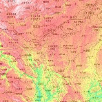
Nombre: Mapa topográfico Anshun, altitud, relieve.
Lugar: Anshun, Guizhou, 561000, China (25.35700 105.24768 26.62836 106.56469)
Altitud media: 1.227 m
Altitud mínima: 363 m
Altitud máxima: 2.139 m
Haz una donación
Otros mapas topográficos
Haga clic en un mapa para ver su topografía, su altitud y su relieve.
Fanjing Mountain
China > Guizhou > Yinjiang Tujia and Miao Autonomous County
The Fanjingshan (Chinese: 梵净山; pinyin: Fànjìngshān) or Mount Fanjing, located in Tongren, Guizhou province, is the highest peak of the Wuling Mountains in southeastern China, at an elevation of 2,570 m (8,430 ft). The Fanjingshan National Nature Reserve was established in 1978 and designated a UNESCO…
Altitud media: 2.054 m
Haz una donación
Haz una donación
Haz una donación
Haz una donación
Haz una donación
Haz una donación
Fanjingshan
The Fanjingshan (Chinese: 梵净山; pinyin: Fànjìngshān) or Mount Fanjing, located in Tongren, Guizhou province, is the highest peak of the Wuling Mountains in southwestern China, at an elevation of 2,570 m (8,430 ft). The Fanjingshan National Nature Reserve was established in 1978 and designated a UNESCO…
Altitud media: 1.958 m
Shandong
China > Guizhou > Qiandongnan Miao and Dong Autonomous Prefecture > Shandong
Altitud media: 1.000 m
Haz una donación
Bijie
Bijie borders Zunyi to the east, Anshun and Liupanshui to the south, Zhaotong and Qujing (Yunnan) to the west, and Luzhou (Sichuan) to the north. It spans latitude 26°21′−27°46′ N and longitude 105°36′−106°43′ E, and is marked heavily by the presence of the Wumeng Mountains (乌蒙山) as well…
Altitud media: 1.651 m
Haz una donación