
Haz una donación
Mapa topográfico Sugar Mountain
Haga clic en el mapa para ver la altitud.
Haz una donación
Sugar Mountain
Sugar Mountain has a humid continental climate (Dfb) with warm summers and moderately cold winters, though very cold by North Carolina standards. Due to the village's high elevation, one can experiences all four seasons in equal length on the mountain.
Haz una donación
Acerca de este mapa
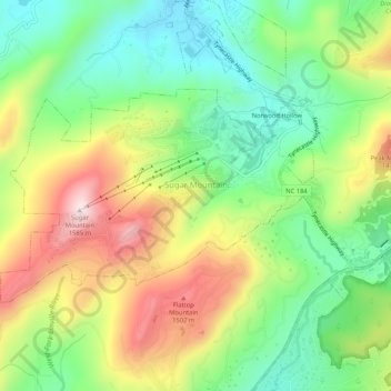
Nombre: Mapa topográfico Sugar Mountain, altitud, relieve.
Lugar: Sugar Mountain, Avery County, North Carolina, United States (36.11463 -81.88628 36.13769 -81.83397)
Altitud media: 1.311 m
Altitud mínima: 1.121 m
Altitud máxima: 1.584 m
Haz una donación
Otros mapas topográficos
Haga clic en un mapa para ver su topografía, su altitud y su relieve.
Haz una donación
Haz una donación
Sugar Mountain
United States > North Carolina > Avery County > Sugar Mountain
Sugar Mountain is a mountain in the North Carolina High Country and wholly in the Pisgah National Forest. Its elevation reaches 5,236 feet (1,596 m) and is split along the Eastern Continental Divide, generating feeder streams for the Linville, Elk, and North Toe rivers. On its north slope resides the Village…
Altitud media: 1.385 m
Beech Mountain
United States > North Carolina > Avery County > Beech Mountain
Beech Mountain is a mountain in the North Carolina High Country and wholly in the Pisgah National Forest. Its elevation reaches 5,506 feet (1,657 m) and generates feeder streams for the Elk River. Nestled on the top is the Town of Beech Mountain.
Altitud media: 1.433 m
Haz una donación