
Gracias por apoyar a este sitio ❤️
Haz una donación
Haz una donación
Mapa topográfico Ranipur
Haga clic en el mapa para ver la altitud.
Gracias por apoyar a este sitio ❤️
Haz una donación
Haz una donación
Acerca de este mapa
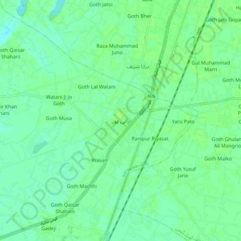
Nombre: Mapa topográfico Ranipur, altitud, relieve.
Altitud media: 52 m
Altitud mínima: 47 m
Altitud máxima: 55 m
Gracias por apoyar a este sitio ❤️
Haz una donación
Haz una donación
Otros mapas topográficos
Haga clic en un mapa para ver su topografía, su altitud y su relieve.
Nara Canal
Left Bank Outfall Drain to the west of Nara Canal, built much later (starting in the 1960s and 80s) than Nara Canal, the LBOD was designed to solve the waterlogging and salinity problems caused by intensive irrigation from canals like the Nara. It collects salty groundwater and industrial/agricultural waste…
Altitud media: 37 m