
Haz una donación
Mapa topográfico Şanlıurfa
Haga clic en el mapa para ver la altitud.
Haz una donación
Şanlıurfa
An important consideration in domestic architecture is mahremiyat, which could roughly be translated into English as "privacy" or "intimacy" but which carries stronger implications. This concept is especially important when it comes to relations between men and women – outside the extended family, interaction between men and women is restricted. As a result, traditional Urfa houses are constructed in ways to prevent men outside from viewing the women of the household. For example, doors facing each other, windows facing the street, and significant differences in roof elevation are all avoided.
Haz una donación
Acerca de este mapa
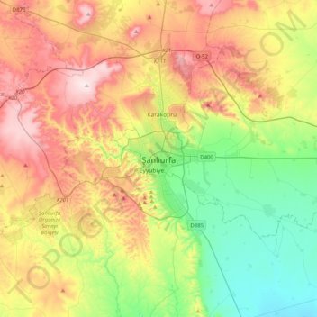
Nombre: Mapa topográfico Şanlıurfa, altitud, relieve.
Altitud media: 623 m
Altitud mínima: 387 m
Altitud máxima: 953 m
Haz una donación
Otros mapas topográficos
Haga clic en un mapa para ver su topografía, su altitud y su relieve.