
Gracias por apoyar a este sitio ❤️
Haz una donación
Haz una donación
Mapa topográfico Vitré
Haga clic en el mapa para ver la altitud.
Gracias por apoyar a este sitio ❤️
Haz una donación
Haz una donación
Vitré
The land area of Vitré: 37.19 km2 (14.36 sq mi). The average altitude of Vitré is approximately 89 m. The highest point, 127 m, is found in the "Ménardières" zone, at Pierre and Marie Curie Street. The lowest point, 67 m, is close to the firm S.V.A.'s location under the viaduct of the ring-road.
Gracias por apoyar a este sitio ❤️
Haz una donación
Haz una donación
Acerca de este mapa
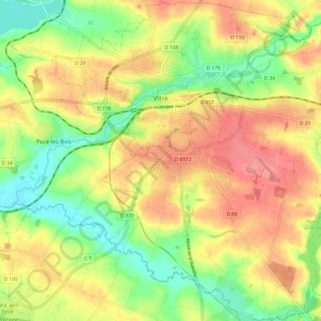
Nombre: Mapa topográfico Vitré, altitud, relieve.
Altitud media: 94 m
Altitud mínima: 52 m
Altitud máxima: 132 m
Gracias por apoyar a este sitio ❤️
Haz una donación
Haz una donación