
Mapa topográfico Britain
Haga clic en el mapa para ver la altitud.
Acerca de este mapa
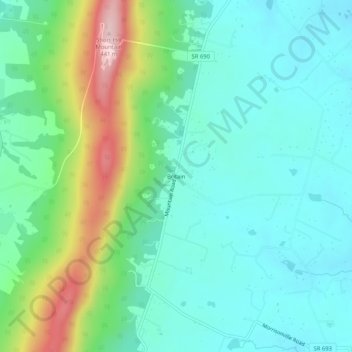
Nombre: Mapa topográfico Britain, altitud, relieve.
Lugar: Britain, Loudoun County, Virginia, United States (39.23288 -77.71694 39.27288 -77.67694)
Altitud media: 215 m
Altitud mínima: 138 m
Altitud máxima: 435 m
Otros mapas topográficos
Haga clic en un mapa para ver su topografía, su altitud y su relieve.
Blue Ridge
United States > Virginia > Loudoun County
Blue Ridge Mountain is noticeably lower in elevation than other sections of the Blue Ridge Mountains in Virginia. The southern section of the mountain contains the highest peaks, and the ridge gradually loses elevation as it gets closer to the Potomac. Elevations in the gaps are typically around 1,000 feet…
Altitud media: 183 m
Loudoun Valley Estates
United States > Virginia > Loudoun County
The land around Loudoun Valley Estates is gently rolling. The average elevation is 289 feet (88 m). The population density is about 500 people per square kilometer.
Altitud media: 89 m
Washington & Old Dominion Trail Regional Park
United States > Virginia > Loudoun County > Purcellville
Altitud media: 162 m