
Haz una donación
Mapa topográfico Dandong
Haga clic en el mapa para ver la altitud.
Haz una donación
Acerca de este mapa
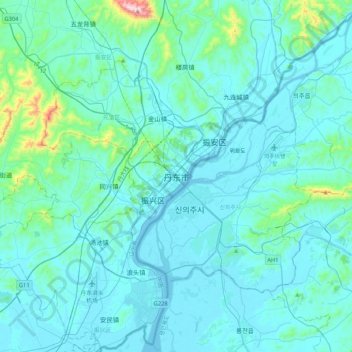
Nombre: Mapa topográfico Dandong, altitud, relieve.
Altitud media: 58 m
Altitud mínima: -3 m
Altitud máxima: 672 m
Haz una donación
Otros mapas topográficos
Haga clic en un mapa para ver su topografía, su altitud y su relieve.
Shenyang City
Shenyang ranges in latitude from 41° 11' to 43° 02' N and in longitude from 122° 25' to 123° 48' E, and is located in the central part of Liaoning province. The western parts of the city's administrative area are located on the alluvial plain of the Liao River system, while the eastern part consists of the…
Altitud media: 151 m
Anshan City
Local transportation is primarily by bus or taxi. Anshan used to have a single tram line—along Zhonghua Avenue, through the city centre and past Angang main gate—but this has been closed and the tracks removed. Due to the flat topography of the city centre, bicycles are popular. Almost all roads have a…
Altitud media: 145 m
Haz una donación
Haz una donación