
Mapa topográfico Zell (Mosel)
Mapa interactivo
Haga clic en el mapa para ver la altitud.
Acerca de este mapa
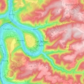
Nombre: Mapa topográfico Zell (Mosel), altitud, relieve.
Altitud media: 287 m
Altitud mínima: 89 m
Altitud máxima: 458 m
Zell is an hour's drive from both Koblenz and Trier, more or less halfway between these two cities. The nearest town going towards Koblenz is Cochem, and the nearest two going towards Trier are Traben-Trarbach and Bernkastel-Kues. To both Frankfurt-Hahn Airport on the Hunsrück and the spa town of Bad Bertrich in the Voreifel it is half an hour's drive. The parts of town lying on the river, the Old Town, Kaimt and Merl, are at an elevation of roughly 100 m above sea level on a remarkable bow in the river Moselle, known as the Zeller Hamm.
Otros mapas topográficos
Haga clic en un mapa para ver su topografía, su altitud y su relieve.
Bullay
Germany > Rhineland-Palatinate > Landkreis Cochem-Zell
Bullay, Zell (Mosel), Landkreis Cochem-Zell, Rhineland-Palatinate, Germany
Altitud media: 207 m
Ulmen
Germany > Rhineland-Palatinate > Landkreis Cochem-Zell
Ulmen, Landkreis Cochem-Zell, Rhineland-Palatinate, 56766, Germany
Altitud media: 455 m
Moselhöhe Ediger-Eller
Germany > Rhineland-Palatinate > Landkreis Cochem-Zell > Ediger-Eller
Moselhöhe Ediger-Eller, Ediger-Eller, Cochem, Landkreis Cochem-Zell, Rhineland-Palatinate, 56814, Germany
Altitud media: 285 m
Cochem
Germany > Rhineland-Palatinate > Landkreis Cochem-Zell
Cochem, Landkreis Cochem-Zell, Rhineland-Palatinate, Germany
Altitud media: 286 m
Beilstein
Germany > Rhineland-Palatinate > Landkreis Cochem-Zell
Beilstein, Cochem, Landkreis Cochem-Zell, Rhineland-Palatinate, Germany
Altitud media: 234 m
Bremm
Germany > Rhineland-Palatinate > Landkreis Cochem-Zell
Bremm, Cochem, Landkreis Cochem-Zell, Rhineland-Palatinate, Germany
Altitud media: 258 m
Neef
Germany > Rhineland-Palatinate > Landkreis Cochem-Zell > Neef
Neef, Zell (Mosel), Landkreis Cochem-Zell, Rhineland-Palatinate, Germany
Altitud media: 213 m