
Gracias por apoyar a este sitio ❤️
Haz una donación
Haz una donación
Mapa topográfico Genting Island
Haga clic en el mapa para ver la altitud.
Gracias por apoyar a este sitio ❤️
Haz una donación
Haz una donación
Acerca de este mapa
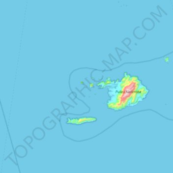
Nombre: Mapa topográfico Genting Island, altitud, relieve.
Altitud media: 8 m
Altitud mínima: -1 m
Altitud máxima: 935 m
Gracias por apoyar a este sitio ❤️
Haz una donación
Haz una donación
Otros mapas topográficos
Haga clic en un mapa para ver su topografía, su altitud y su relieve.
Pulau Maya
Indonesia > West Kalimantan > Kayong Utara
Maya Karimata (now just called Maya or Maja) is an island in North Kayong Regency in West Kalimantan Province, Indonesia. Its area is 992.1 square kilometres (383.1 square miles). Maya Island and the Karimata Islands formerly comprised a single administrative district (kecamatan) within the Regency, but it has…
Altitud media: 4 m
Gracias por apoyar a este sitio ❤️
Haz una donación
Haz una donación
Gracias por apoyar a este sitio ❤️
Haz una donación
Haz una donación