
Gracias por apoyar a este sitio ❤️
Haz una donación
Haz una donación
Mapa topográfico Tenterden
Haga clic en el mapa para ver la altitud.
Gracias por apoyar a este sitio ❤️
Haz una donación
Haz una donación
Acerca de este mapa
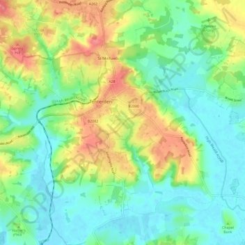
Nombre: Mapa topográfico Tenterden, altitud, relieve.
Lugar: Tenterden, Ashford, Kent, England, United Kingdom (51.02750 0.64253 51.09999 0.75704)
Altitud media: 28 m
Altitud mínima: -1 m
Altitud máxima: 78 m
Gracias por apoyar a este sitio ❤️
Haz una donación
Haz una donación
Otros mapas topográficos
Haga clic en un mapa para ver su topografía, su altitud y su relieve.