
Haz una donación
Mapa topográfico Poličnik
Haga clic en el mapa para ver la altitud.
Haz una donación
Acerca de este mapa
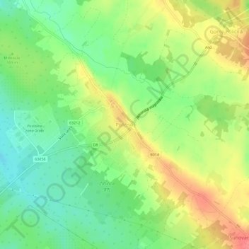
Nombre: Mapa topográfico Poličnik, altitud, relieve.
Lugar: Poličnik, Općina Poličnik, Zadar County, 23241, Croatia (44.15430 15.35846 44.19430 15.39846)
Altitud media: 96 m
Altitud mínima: 64 m
Altitud máxima: 135 m
Haz una donación
Otros mapas topográficos
Haga clic en un mapa para ver su topografía, su altitud y su relieve.
Haz una donación
Haz una donación
National park Paklenica
The central part of the Park is distinctive for the relief complex of Borovnik and Crni vrh, with the valley of Mala Močila and Velika Močila nearby. In terms of relief, Velika Močila is a very interesting bowl-shaped valley at an altitude 850 m asl, surrounded by Crni vrh (1 110 m asl), Škiljina kosa (1…
Altitud media: 853 m
Haz una donación
Zadar
Since records began in 1961, the highest temperature recorded at the local weather station at an elevation of 5 metres (16 ft) was 36.3 °C (97.3 °F), on 4 August 2017. The coldest temperature was −9.1 °C (15.6 °F), on 23 January 1963.
Altitud media: 29 m
Haz una donación
Haz una donación
Haz una donación
Haz una donación
Haz una donación
Haz una donación
Haz una donación
Zadar
Since records began in 1961, the highest temperature recorded at the local weather station at an elevation of 5 metres (16 ft) was 36.3 °C (97.3 °F), on 4 August 2017. The coldest temperature was −9.1 °C (15.6 °F), on 23 January 1963.
Altitud media: 29 m
Haz una donación
Bijela
Croatia > Zadar County > Grad Obrovac > Gornji Karin
Bijela is one of the smallest rivers in northern Dalmatia, flowing from east to west, and enters Karin Sea at Gornji Karin, a village belonging to the Town of Obrovac in the Zadar County. The spring of Bijela is located at an altitude of approximately 300 meters, below the Pržun mountain peak (351 meters…
Altitud media: 87 m
Haz una donación
Haz una donación
Lake Vrana
Croatia > Zadar County > Općina Pakoštane
The area of the lake is 30.7 square kilometres (11.9 sq mi), the elevation of its surface above sea level is only 0.1 metres (0.33 ft), while its maximum depth is 4 metres (13 ft).
Altitud media: 44 m
Haz una donación
Dugi Otok
Dugi Otok (pronounced [dûɡiː ǒtok]; Croatian for "long Island", Italian: Isola Lunga) is part of Croatia and the seventh largest island in the Adriatic Sea. It is located off the Dalmatian coast, west of Zadar. It is the largest and westernmost of the Zadarian Islands, and derives its name from its…
Altitud media: 11 m
Haz una donación