
Haz una donación
Mapa topográfico Viking Quarry Lake
Haga clic en el mapa para ver la altitud.
Haz una donación
Acerca de este mapa
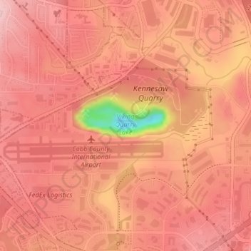
Nombre: Mapa topográfico Viking Quarry Lake, altitud, relieve.
Lugar: Viking Quarry Lake, Cobb County, Georgia, United States (34.01451 -84.59792 34.01711 -84.58491)
Altitud media: 303 m
Altitud mínima: 166 m
Altitud máxima: 340 m
Haz una donación
Otros mapas topográficos
Haga clic en un mapa para ver su topografía, su altitud y su relieve.
Kennesaw Mountain
United States > Georgia > Cobb County
Kennesaw Mountain is a mountain between Marietta and Kennesaw, Georgia in the United States with a summit elevation of 1,808 feet (551 m). It is the highest point in the core (urban and suburban) metro Atlanta area, and fifth after further-north exurban counties are considered. The local terrain averages…
Altitud media: 360 m
Haz una donación
Kennesaw
United States > Georgia > Cobb County > Kennesaw
Kennesaw is located in northwestern Cobb County, bordered by the city of Acworth to the northwest. Kennesaw Mountain is located southeast of the city limits in the battlefield park. Its summit is the highest point in the Atlanta metro area, at an elevation of 1,808 feet (551 m) above sea level. The city was…
Altitud media: 318 m
Haz una donación