
Haz una donación
Mapa topográfico Tripoli
Haga clic en el mapa para ver la altitud.
Haz una donación
Tripoli
The city of Tripoli has a hot-summer Mediterranean climate (Köppen: Csa). Ιt is located in the center of the Peloponnese, at the western border of a large basin (a polje at about 650 m in altitude, a length of ca. 30 km and a width between 12,5 and 2,5 km). The city is today the capital of the regional unit Arcadia (residents, city alone, ca. 30 000, district with hinterland ca. 47500, 2011 Greek census). At its west the city borders the thickly wooded mountain-area “Mainalo”. The Tripoli Basin has gradually been rainwater regulated (mainly after 1945) and turned into farmland. In the southwest floods, which appear in the basin occasionally after rainy winters, as in 2003, formed the temporary Lake Taka. This lake was regulated by a new pond, to retain water for irrigation.
Haz una donación
Acerca de este mapa
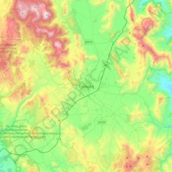
Nombre: Mapa topográfico Tripoli, altitud, relieve.
Altitud media: 873 m
Altitud mínima: 274 m
Altitud máxima: 1.966 m
Haz una donación
Otros mapas topográficos
Haga clic en un mapa para ver su topografía, su altitud y su relieve.