
Gracias por apoyar a este sitio ❤️
Haz una donación
Haz una donación
Mapa topográfico Unga
Haga clic en el mapa para ver la altitud.
Gracias por apoyar a este sitio ❤️
Haz una donación
Haz una donación
Unga
55°11′03″N 160°30′18″W / 55.18417°N 160.50500°W / 55.18417; -160.50500 Unga (Unangam tunuu: Uĝnaasaqax̂) is a ghost town on Unga Island in the Aleutians East Borough of the U.S. state of Alaska, about two miles west of Sand Point. The island's length is 15 miles (24 km). Unga's altitude is 59 feet (18 m).
Gracias por apoyar a este sitio ❤️
Haz una donación
Haz una donación
Acerca de este mapa
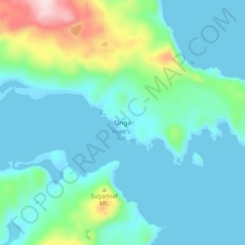
Nombre: Mapa topográfico Unga, altitud, relieve.
Lugar: Unga, Aleutians East, Alaska, United States (55.16344 -160.52753 55.20344 -160.48753)
Altitud media: 56 m
Altitud mínima: -4 m
Altitud máxima: 305 m
Gracias por apoyar a este sitio ❤️
Haz una donación
Haz una donación
Otros mapas topográficos
Haga clic en un mapa para ver su topografía, su altitud y su relieve.