
Gracias por apoyar a este sitio ❤️
Haz una donación
Haz una donación
Mapa topográfico Misool Archipelago
Haga clic en el mapa para ver la altitud.
Gracias por apoyar a este sitio ❤️
Haz una donación
Haz una donación
Acerca de este mapa
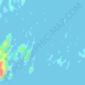
Nombre: Mapa topográfico Misool Archipelago, altitud, relieve.
Altitud media: 3 m
Altitud mínima: -2 m
Altitud máxima: 98 m
Gracias por apoyar a este sitio ❤️
Haz una donación
Haz una donación
Otros mapas topográficos
Haga clic en un mapa para ver su topografía, su altitud y su relieve.
Pulau Waigeo
Indonesia > Southwest Papua > Raja Ampat
The area of the island is 3,155 square kilometres (1,218 square miles); the highest elevations are 958-metre-high (3,143-foot) Buffalo Horn (Gunung Nok) and 939-metre-high (3,081-foot) Serodjil. From west to east, the island measures approximately 110 km (68 mi), north–south about 50 kilometres (31 miles).
Altitud media: 37 m