
Haz una donación
Mapa topográfico Sampit
Haga clic en el mapa para ver la altitud.
Haz una donación
Acerca de este mapa
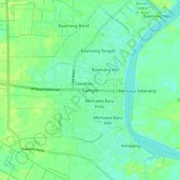
Nombre: Mapa topográfico Sampit, altitud, relieve.
Lugar: Sampit, Central Kalimantan, 74322, Indonesia (-2.57891 112.90939 -2.49891 112.98939)
Altitud media: 7 m
Altitud mínima: 1 m
Altitud máxima: 13 m
Haz una donación
Otros mapas topográficos
Haga clic en un mapa para ver su topografía, su altitud y su relieve.
Haz una donación
Palangka Raya
Indonesia > Central Kalimantan
Palangka Raya borders Gunung Mas Regency to the north, Katingan Regency to the west, and Pulang Pisau Regency to the south and east. The area's soil consists mostly of peat and alluvium in its southern part and podzol on the northern part of the city. Overall, podzol soil dominates the city soil with 218,486…
Altitud media: 23 m
Haz una donación
Murung Raya
Indonesia > Central Kalimantan
The regency has an area of 23,700 km2 and lies between 114°27'00 to 115°49'00 East longitude and 0°58'30 North latitude to 1°26'00 South latitude. It occupies the valleys and foothills of the southern and eastern slopes of the Müller Mountains, and rises to 1730 m at Mount Lesung on its northern border.…
Altitud media: 365 m
South Barito
Indonesia > Central Kalimantan
Regency's topography is flat and low-lying but on the most part except on northern parts where mountain ranges could be found. The regency's low-lying regions are wetlands and swamps with little variations.
Altitud media: 38 m
Haz una donación
Haz una donación
Palangka Raya
Indonesia > Central Kalimantan
Palangka Raya borders Gunung Mas Regency to the north, Katingan Regency to the west, and Pulang Pisau Regency to the south and east. The area's soil consists mostly of peat and alluvium in its southern part and podzol on the northern part of the city. Overall, podzol soil dominates the city soil with 218,486…
Altitud media: 23 m
Haz una donación