
Gracias por apoyar a este sitio ❤️
Haz una donación
Haz una donación
Mapa topográfico The Three Peaks
Haga clic en el mapa para ver la altitud.
Gracias por apoyar a este sitio ❤️
Haz una donación
Haz una donación
Acerca de este mapa
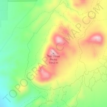
Nombre: Mapa topográfico The Three Peaks, altitud, relieve.
Lugar: The Three Peaks, Iron County, Utah, United States (37.76104 -113.20250 37.76114 -113.20240)
Altitud media: 1.789 m
Altitud mínima: 1.653 m
Altitud máxima: 1.944 m
Gracias por apoyar a este sitio ❤️
Haz una donación
Haz una donación
Otros mapas topográficos
Haga clic en un mapa para ver su topografía, su altitud y su relieve.