
Haz una donación
Mapa topográfico Gallarate
Haga clic en el mapa para ver la altitud.
Haz una donación
Gallarate
Founded by the Gauls and later conquered by the Romans, Gallarate was mentioned as an important vicus or village in documents dating back to the Roman conquest of what was then called Gallia Cisalpina. After the Carolingian conquest of northern-central Italy, a castle was erected upon the remains of the original Roman fortifications located beside the still-existing Basilica of Santa Maria. The castle has disappeared, but its ancient location is identified through the city's topography and by the street name Via Postcastello.
Haz una donación
Acerca de este mapa
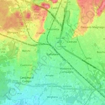
Nombre: Mapa topográfico Gallarate, altitud, relieve.
Lugar: Gallarate, Varese, Lombardy, 21013, Italy (45.63119 8.75368 45.69043 8.83244)
Altitud media: 254 m
Altitud mínima: 222 m
Altitud máxima: 309 m
Haz una donación
Otros mapas topográficos
Haga clic en un mapa para ver su topografía, su altitud y su relieve.
Pianca
Italy > Lombardy > Varese > Maccagno con Pino e Veddasca > Maccagno Superiore
Altitud media: 364 m
Parco archeologico di Castel Seprio
Italy > Lombardy > Varese > Castelseprio > Vico Seprio
Altitud media: 314 m
Haz una donación