
Haz una donación
Mapa topográfico Temple Hills
Haga clic en el mapa para ver la altitud.
Haz una donación
Acerca de este mapa
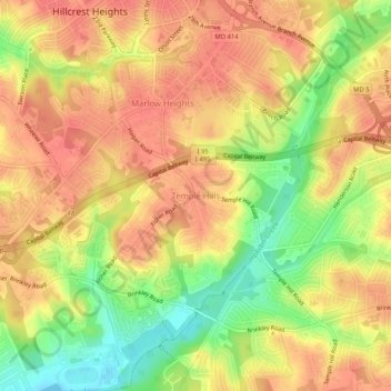
Nombre: Mapa topográfico Temple Hills, altitud, relieve.
Altitud media: 66 m
Altitud mínima: 27 m
Altitud máxima: 89 m
Haz una donación
Otros mapas topográficos
Haga clic en un mapa para ver su topografía, su altitud y su relieve.
University Park
United States > Maryland > Prince George's County > University Park
University Park was developed on land owned by the Deakins family since the mid-1700s. The house known as Deakins Hall or Bloomfield was constructed on the land in the 1820s or 1830s. It is located at 6404 Queens Chapel Road. The farm was purchased by the University Park Company in 1923. The extension of water…
Altitud media: 29 m
Haz una donación
Haz una donación
Rosaryville State Park
United States > Maryland > Prince George's County > Upper Marlboro
Altitud media: 59 m
Haz una donación
Haz una donación
Mount Rainier Community Food Forest
United States > Maryland > Prince George's County > Mount Rainier
Altitud media: 23 m