
Mapa topográfico Haywood County
Mapa interactivo
Haga clic en el mapa para ver la altitud.
Acerca de este mapa
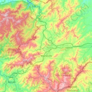
Nombre: Mapa topográfico Haywood County, altitud, relieve.
Lugar: Haywood County, North Carolina, United States (35.29115 -83.25611 35.79002 -82.74448)
Altitud media: 1.045 m
Altitud mínima: 477 m
Altitud máxima: 1.998 m
Haywood County is situated amidst the Blue Ridge Mountains and contains parts of several major subranges of the Blue Ridge, namely the Great Smoky Mountains in the west and the Plott Balsams and Great Balsam Mountains in the south. Notable peaks in the county include Cold Mountain, at 6,030 feet (1,840 m), Mount Sterling, at 5,835 feet (1,779 m), and Richland Balsam, at 6,410 feet (1,950 m) in elevation. Mt. Guyot, the county's highest point at 6,621 feet (2,018 m), is the 4th highest mountain east of the Mississippi River. Black Balsam Knob, in the Great Balsam Mountains in the southeastern section of the county, is the highest grassy bald in the entire Appalachian range. Haywood County is believed to be the highest county (by mean elevation) east of the Mississippi River, with a mean elevation of 3600 feet (1095m).
Otros mapas topográficos
Haga clic en un mapa para ver su topografía, su altitud y su relieve.
Guilford County
United States > North Carolina
Guilford County, North Carolina, United States
Altitud media: 239 m