
Haz una donación
Mapa topográfico Kornet
Haga clic en el mapa para ver la altitud.
Haz una donación
Acerca de este mapa
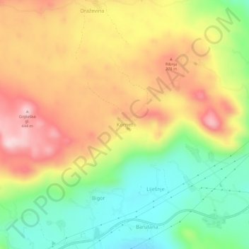
Nombre: Mapa topográfico Kornet, altitud, relieve.
Lugar: Kornet, Podgorica Capital City, 81252, Montenegro (42.39077 19.12046 42.43077 19.16046)
Altitud media: 271 m
Altitud mínima: 110 m
Altitud máxima: 444 m
Haz una donación
Otros mapas topográficos
Haga clic en un mapa para ver su topografía, su altitud y su relieve.
Podgorica
Montenegro > Podgorica Capital City
In contrast to most of Montenegro, Podgorica lies in a mainly flat area at the northern end of the Zeta plain, at an elevation of 40 m (130 ft). The only exceptions are hills which overlook the city. The most significant is 130.3 m (427 ft) high Gorica Hill (pronounced [ˈɡǒrit͜sa]), city's namesake, which…
Altitud media: 105 m
Haz una donación