
Mapa topográfico Chaul End
Haga clic en el mapa para ver la altitud.
Acerca de este mapa
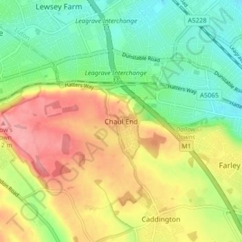
Nombre: Mapa topográfico Chaul End, altitud, relieve.
Altitud media: 159 m
Altitud mínima: 114 m
Altitud máxima: 215 m
Otros mapas topográficos
Haga clic en un mapa para ver su topografía, su altitud y su relieve.
Northill
United Kingdom > England > Central Bedfordshire
Topographically, Northill stands on a slightly elevated ridge that runs north to south. The village lies on the border of the Bedfordshire and Cambridgeshire Claylands and the Bedfordshire Greensand Ridge; National Character Areas designated by Natural England. Central Bedfordshire Council has classified the…
Altitud media: 37 m
Dunstable Downs
United Kingdom > England > Central Bedfordshire > Church End
Because of its elevation, Dunstable Downs hosted a station in the shutter telegraph chain which connected the Admiralty in London to its naval ships in the port of Great Yarmouth during the years 1808 to 1814.
Altitud media: 178 m
Edgecote
United Kingdom > England > Central Bedfordshire > Caddington > Aley Green
Altitud media: 168 m
Houghton Hall Park
United Kingdom > England > Central Bedfordshire > Houghton Regis
Altitud media: 134 m
Leighton-Linslade
United Kingdom > England > Central Bedfordshire > Leighton Buzzard
Altitud media: 100 m
Wrestlingworth and Cockayne Hatley
United Kingdom > England > Central Bedfordshire
Altitud media: 51 m
Husborne Crawley
United Kingdom > England > Central Bedfordshire > Husborne Crawley
Altitud media: 97 m
Totternhoe Knolls
United Kingdom > England > Central Bedfordshire > Church End > Lower End
Altitud media: 105 m
Crawley Park
United Kingdom > England > Central Bedfordshire > Aspley Guise > Husborne Crawley
Altitud media: 98 m