
Gracias por apoyar a este sitio ❤️
Haz una donación
Haz una donación
Mapa topográfico Città di Castello
Haga clic en el mapa para ver la altitud.
Gracias por apoyar a este sitio ❤️
Haz una donación
Haz una donación
Acerca de este mapa
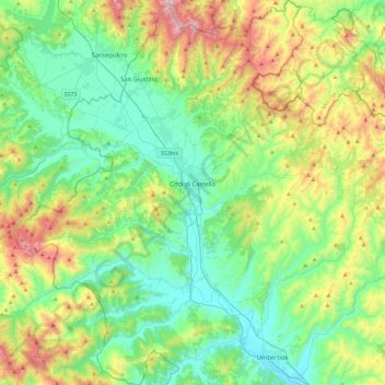
Nombre: Mapa topográfico Città di Castello, altitud, relieve.
Lugar: Città di Castello, Perugia, Umbria, Italy (43.28135 12.07278 43.61734 12.43482)
Altitud media: 504 m
Altitud mínima: 230 m
Altitud máxima: 1.213 m
Gracias por apoyar a este sitio ❤️
Haz una donación
Haz una donación
Otros mapas topográficos
Haga clic en un mapa para ver su topografía, su altitud y su relieve.
San Leo Bastia
Italy > Umbria > Perugia > Città di Castello
San Leo Bastia is a frazione of the comune of Città di Castello in the Province of Perugia, Umbria, central Italy. It stands at an elevation of 320 metres above sea level. At the time of the Istat census of 2001 it had 213 inhabitants.
Altitud media: 404 m